This guide will help to interpret application setback requirements found on atrazine product labels. The MDA will be inspecting and enforcing the use requirements for atrazine products based on labeling and these interpretations. It should be noted, however, that final determinations for the MDA enforcement action are made on a site- and case-specific basis.
Water bodies included under "perennial or intermittent streams and rivers"
Atrazine product labels prohibit the application of atrazine within 66 feet of the point where field surface water runoff enters perennial or intermittent streams and rivers.
The MDA interprets “perennial streams and rivers” to include natural surface water channels which have flowing water throughout the year.
The MDA interprets “intermittent streams and rivers” to include natural surface water channels which flow only during wet periods of the year and which have water flowing at the time of application.
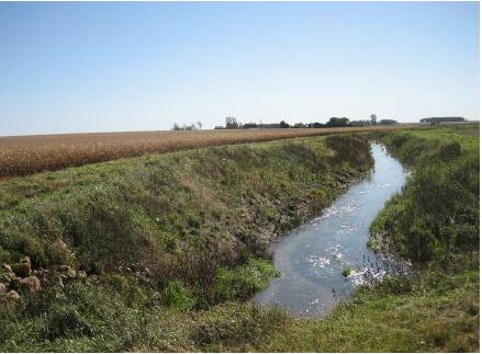
Man-made ditches also require the 66 foot application setback if they have flowing water throughout the year or have been identified as a perennial or intermittent stream on a 1:24,000 scale U.S. Geological Survey (USGS) topographical map.1
The application setback is not required for roadside ditches, grass waterways and other man-made features that are designed to channel runoff and reduce erosion.
Water bodies included under "lakes and reservoirs"
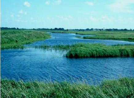
The MDA interprets “natural or impounded lakes and reservoirs” to exclude farm ponds. A farm pond is a
water impoundment made by constructing a dam or an embankment, or by excavating a pit or dugout. They are exempt from the 200 foot application setback requirement when they meet all the following criteria:
- they are located wholly on the farmer’s property;
- they are not used for human drinking water; and,
- they do not discharge into a lake or a perennial or intermittent stream or river directly or through a clearly defined water course.
Any other lake or reservoir that does not meet the definition of a farm pond requires the 200 foot atrazine application setback. This includes wetlands which have open water all year.
Use restrictions for tile-outletted fields containing standpipes
Atrazine products vary in their label language regarding use restriction in tile-outletted fields which contain standpipes. Some labels restrict atrazine use in tile-outletted fields with standpipes only when the fields are terraced. Other labels restrict atrazine use in all tile-outletted fields with standpipes, whether they are terraced or not. Read and follow the label for the specific atrazine product being used.
When a label restricts atrazine use because standpipes are present, one of these three restrictions need to be followed:
- Do not apply this product within 66 feet of standpipes in tile-outletted (terraced) fields, or,
- Apply this product to the entire tile-outletted (terraced) field and immediately incorporate it to a depth of 2-3 inches in the entire field, or,
- Apply this product to the entire tile-outletted (terraced) field under a no-till practice only when a high crop residue management practice is used.
The MDA interprets “standpipes” to include all surface tile inlets that are designed to drain surface water, such as slotted riser pipes, open inlets, rock inlets, or other functionally equivalent open surface drains. The MDA does not consider non-slotted tile riser pipes, which only function to provide air to the subterranean tile system, to be standpipes.
Where to measure from when determining atrazine application set-back distances
Wells: 50 foot application setbacks from wells are measured from the point on the borehole or dug hole closest to where atrazine is applied. Setback can be circular if the well is located within the field.
Sinkholes: 50 foot application setbacks from sinkholes are measured from the point where the ground begins to slope downward into the depression. The setback can be circular if the sinkhole is located within the field.
Surface water: 66 foot application setbacks from streams and rivers and 200 foot application setbacks from lakes and reservoirs are measured from the water’s edge at the time of atrazine application.

Inlets near surface water: If a solitary inlet (not part of a larger tiling network) to a subsurface tile or culvert is within 66 feet of a stream or river or 200 feet of a lake or reservoir and the tile or culvert outlets into the body of water, an application setback is required and is measured from the point on the inlet closest to where atrazine is applied.
Standpipes (surface tile inlets): 66 foot application setbacks from standpipes in tile outletted fields are measured from the edge of the standpipe (inlet) closest to where atrazine is applied. Setbacks can be circular in fields without terraces. In fields with terraces, the setback does not need to extend past the base of the down slope terrace berm; in those cases the setback can be semi-circular. Application setbacks are not required around all standpipes (see discussion at the top of this page).
Notes
1 USGS topographical maps of different scales can map water features differently. Applicators are advised to use 1:24,000 scale maps, also called 7.5-minute quadrangle maps, because they are the most accurate. These maps can be downloaded or purchased from the USGS online store, using the "Map Locator Tool". Select “7.5 X 7.5” grid maps to obtain maps in 1:24,000 scale.